


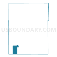
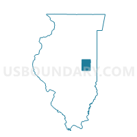
SADORUS-SADORUS Voting District, Champaign County, Illinois
About
Outline

Summary
| Unique Area Identifier | 564791 |
| Name | SADORUS-SADORUS Voting District |
| County | Champaign County |
| State | Illinois |
| Area (square miles) | 19.86 |
| Land Area (square miles) | 19.80 |
| Water Area (square miles) | 0.05 |
| % of Land Area | 99.73 |
| % of Water Area | 0.27 |
| Latitude of the Internal Point | 39.93043960 |
| Longtitude of the Internal Point | -88.37696050 |
Maps

Graphs
Select a template below for downloading or customizing gragh for SADORUS-SADORUS Voting District, Champaign County, Illinois


Neighbors
Neighoring Voting District (by Name) Neighboring Voting District on the Map
- COLFAX Voting District, Champaign County, IL
- GARRETT 1 Voting District, Douglas County, IL
- PESOTUM Voting District, Champaign County, IL
- SADORUS-IVESDALE Voting District, Champaign County, IL
- TOLONO 3 Voting District, Champaign County, IL
- TUSCOLA 2 Voting District, Douglas County, IL
Top 10 Neighboring County Subdivision (by Population) Neighboring County Subdivision on the Map
- Tolono township, Champaign County, IL (5,270)
- Tuscola township, Douglas County, IL (5,259)
- Garrett township, Douglas County, IL (1,441)
- Sadorus township, Champaign County, IL (967)
- Pesotum township, Champaign County, IL (845)
- Colfax township, Champaign County, IL (266)
Top 10 Neighboring Place (by Population) Neighboring Place on the Map
Top 10 Neighboring Unified School District (by Population) Neighboring Unified School District on the Map
- Monticello Community Unit School District 25, IL (9,163)
- Tolono Community Unit School District 7, IL (9,017)
- Tuscola Community Unit School District 301, IL (5,782)
- Atwood-Hammond Community Unit School District 39, IL (2,605)